
Introduction
Computer-based techniques can lead a student to a clearer understanding of problem areas in a subject. The Letts Keyfacts Revision Software provides suites of programs specifically designed to develop insight into these areas of difficulty. Each package contains up to 10 interactive programs based on major topics found in all the current 16+ (O-Level GCE, CSE and GCSE) syllabuses.
As an integral part of a revision scheme the programs will assist understanding and reinforce learning. A variety of approaches is used to maximise the student's interest and to introduce an element of enjoyment of home study. Graphics are presented in an imaginative, interactive way as a positive teaching aid. An illustrated booklet provides information on how to get the most out of the programs.
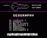
Geography consists of ten interactive programs, approved by subject teachers and tested by students. These are contained on two cassette tapes. Topics included are:
- Mapwork
- Plate tectonics
- The land cycle
- Planet Earth
- The weather map
- Climate and vegetation
- Agriculture
- Industry, fuel and power
- Population
- Settlements
How To Use The Programs In A Revision Scheme
The programs on these cassette tapes have been devised to make your revision more approachable and enjoyable. Organisation is the key to making the most of your revision time. For each subject follow these simple rules.
| 1. | Know your syllabus. A quick reference to the relevant syllabus analysis table to be found at the front of the Letts Study Aid Revise series is advised. |
| 2. | Devise a timetable, as soon as the mocks are over, which will allow you to go through the syllabus at least twice (more for problem areas). |
| 3. | For each topic, read all your available material - class notes and textbooks. Make summary notes as you go, then test yourself. Keyfacts Multiple Choice or Letts Study Aids Objective Questions will give invaluable practice and help. Finally, run the relevant computer program which will both test your knowledge and give you another perspective. |
| 4. | Just before the examination, use all your summary notes to jog your memory and the whole subject program suite to reinforce your understanding. |
The Geography programs are designed to allow you to revise in depth key aspects of the examination syllabus - location, chance, processes, systems are covered. The basic features of both physical and human geography are also covered so that you can go into the examination confident in your understanding of the fundamental aspects of world geography.
The programs have been planned in distinct sections so that if you only have a limited amount of time for revision some evenings you can make the most of the time by selecting a particular portion to study. It also means that you can concentrate upon a particular section or sections when you want to do so. To add to the interest and to cut down revision 'boredom' the style of the programs has been deliberately varied.
1. Landforms 1
In this program erosion by water is revised. The program loads in three parts, each part consisting of a three-dimensional colour diagram. The three parts consider three stages of a river - the upland area, the central section and the lower region. Key features of the river and its valley are shown for each stage. Questions relating to the diagrams appear on screen along with instructions. You are given the opportunity to re-run each section or to load and run the next section at the end of each part of the program.
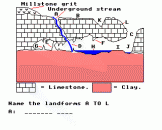
2. Landforms 2
Erosion by water is now studied further; this time the effect of running water on upland limestone regions. This program is in one part. There is a cross-section diagram of a limestone area showing the features both above and below the ground that result from the dissolving of the rock by rainwater. Questions are asked about these features.
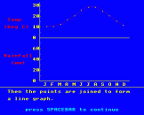
3. Climate
This is designed to reflect the kind of questions you may meet in the examination. Climate graphs are used to illustrate the steps by which you can analyse data in order to establish the type of climate shown and its possible location. The program is in two sections. The first section uses a typical climate graph showing temperature and rainfall and analyses key features such as rainfall pattern, range of temperature, etc. In the second section, you are asked to interpret similar graphs and deduce the type of climate they represent.
4. World Climate
The study of climate is extended to world climatic conditions. A world map is drawn on screen - this takes some time to load and you must leave the tape recorder running until it is complete. Regions are labelled on the map and you are asked about their climates. It would be useful to have an atlas open at a world map when completing this section.
5. Agriculture
This section studies the input-output model of farming as a system which is equally appropriate to farming in the British Isles and to farming in the regions you have studied in detail. A systems diagram of a farm model is built up on screen as you answer questions correctly.
6. Agriculture 2
Types of agriculture in Britain and throughout the world are revised using maps, first of the British Isles, and then an outline map of the world. You are asked to name the regions labelled and the type of farming which is common to them. This program is very useful to help you gain and test knowledge, and again an atlas would be useful.
7. Industry
There are two parts to this program, both studying industrial development. First you are asked questions about factors of location for an iron and steel works, and then a model of location factors is built up on the screen. A map of Llanwern in Gwent is the first object of detailed study, with questions about the site and the origin of the materials involved. The second section of the program studies the iron and steel works of the Damodar Valley in India - a multi-purpose development project.
8. Population
This is another program in two parts, both studying world population graphs. First your interpretation of a world population growth graph is tested. In the second part you are presented with two population pyramids A and B. Only one is shown on screen at a time; to see the other one press C. Questions relating to these graphs are asked and your interpretative skills are tested and reinforced.
9. Settlements 1
The physical characteristics of settlements are discussed, by looking at the situation and morphology of a town. A block diagram summarising the situation of typical British villages is then the object of revision and you are asked to describe the location of various villages. This program illustrates an important field of study since it relates to questions which may be asked on the ordinance survey map, to questions on field work you have done and to studies of the British Isles or other parts of the world.
10. Settlements 2
A diagrammatic representation of a port appears on screen with labelled features which you are asked to identify. You are then shown factors affecting the growth of a port and these are added to the illustration.


